USA
This research is aimed at simulating road travel for the entire continental United States using agent-level activity profiles derived from smartphone-based geospatial big data. The expansive spatial scope of this work allows for the estimation of travel demand for an entire nation in one go. This work may be of value to transportation and planning agencies who are interested in estimating and predicting the system-wide travel demand.
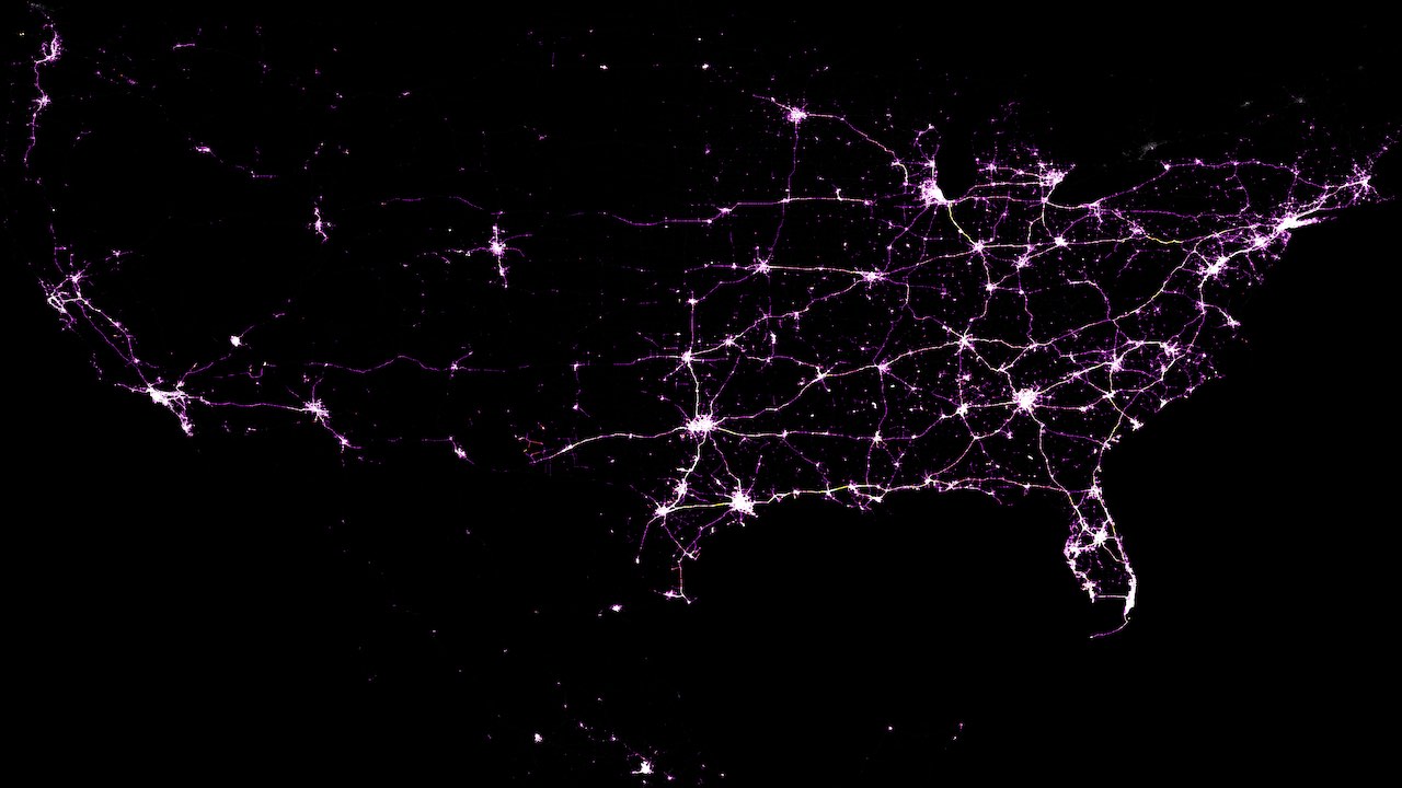
The above figure shows the nationwide road congestion at 9 AM EST. Most of the east coast in the United States is busy with activity and the same holds for the Central time zone. However, activity levels are only higher in the big population centers on the West Coast as it is 6 AM for them.
Research paper
Additional information can be found in the research paper:
Sashikanth Gurram, Vijayaraghavan Sivaraman, Jonathan T. Apple, Abdul R. Pinjari. Agent-based modeling to simulate road travel using Big Data from smartphone GPS: An application to the continental United States. 2019.
Abstract
Growing concerns about urban sustainability, economic and public health vitality, and climate change are common features across the world. Transportation is often inextricably linked to these concerns and this necessitates the development of robust and scalable tools that can assist in timely understanding of the agent-system interactions. Such expedient but accurate analyses are critical for policymaking, especially in the current environment where urban mobility is witnessing a rapid transformation.
To support such analyses, we demonstrate a novel methodology that implements a top-down large-scale agent-based simulation of urban travel using Global Positioning System (GPS) derived raw sightings. Specifically, we constructed the daily activity and travel patterns of devices (i.e. agents) using GPS data for a single day (Wednesday, March 6, 2019) for the entire continental United States. Data filtering techniques were applied to identify approximately 2.7 million smart devices (out of a daily total of 30.5 million) that were highly visible and mobile. We sourced roadway network data for the entire North America from Open Street Maps (OSM). We then fed the daily activity and travel records of agents along with the roadway network data into MATSim, an agent-based travel simulator, to produce highly spatiotemporally resolved agent activities along with their estimated travel trajectories. We processed these travel trajectories (1.5 billion records) to estimate vehicle miles traveled (VMT) for each U.S. state and modeled vehicle volumes per roadway link in the continental U.S.
Overall, we found strong rank correlations between our results and Federal Highway Administration’s VMT estimates, although absolute measures displayed a higher variability. We observed similar trends (i.e. low rank correlation errors but higher absolute errors) at the disaggregate roadway link level when comparing our extrapolated traffic volumes against roadway count station data from a select state (Florida). Finally, root mean squared error of our roadway volume estimates are comparatively similar to those for Florida’s regionwide travel demand models indicating a satisfactory model performance.
The proposed methodology in our study demonstrates that such big data-powered large-scale agent-based simulations may provide value in estimating and predicting travel demand.